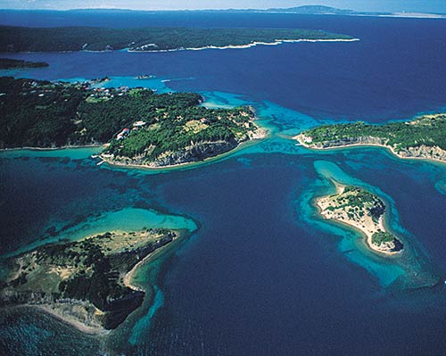
Croatian Islands
Škoji - The Croatian Islands
Vrnik Island
Vrnik island Info
The population on the island is 5 inhabitants with total area on the island 281558 square meters. The population density is inhabitants per square kilometer. The hightest peak on the island is meters. The island is accessible by public transport (ferries).More information:
Vrnik is the second largest island in Korcula Archipelago. This is populated island, with the village of the same name. Vrnik is the site of the oldest and most famous Korcula quarry. There are only couple of families that presently live in this picturesque village, and some of them let rooms and apartments to tourists. Only private boats and taxi boats sail to the island. The nearest parking place for cars is just 100 meters away on the island of Korcula (at the crossroads Krmaca). Next to the local school on the coast there is a church of Our Lady of Succors from 1856. In front of one of the quarries on the northern coast, there is the old church of Our Lady of Succors from 1674.
| GPS Latitude | 42.93514300 |
|---|---|
| GPS Longitude | 17.17170600 |
| Population | 5 |
| Area(M2) | 281558 |
| Coastline Lenght(M) | 2300 |
| Highest peak | |
| Population density |
Vrnik GPS coordinates
GPS location coordinates: 42°56'6.5"N 17°10'18.1"EVrnik Video
Some Lighthouses in vicinity of Vrnik:
- Sestrica vela (Korcula) Lighthouse in Islet Vela Sestrica near Korcula at a distance of 2.63 miles.
- Glavat Lighthouse in Islet Glavat near Lastovo at a distance of 11.77 miles.
- Sucuraj Lighthouse in Sućuraj, Hvar Island at a distance of 13.17 miles.
- Plocica Lighthouse in Islet Plocica near Korcula at a distance of 19.12 miles.
- Struga Lighthouse in Skrivena Luka, Lastovo Island at a distance of 20.58 miles.
- Sveti Petar Lighthouse in Makarska at a distance of 26.16 miles.
- Sveti Nikola Lighthouse in Pucisca, Brac island at a distance of 36.76 miles.
Marinas in vicinity of Vrnik:
- ACI Marina Korcula at a distance of 2.41 miles.
- Marina Solitudo (Lastovo) at a distance of 21.29 miles.
- Marina Ramova ( Baska Voda) at a distance of 28.49 miles.
- ACI Marina Vrboska (Hvar) at a distance of 30.19 miles.
- Marina Baska Voda at a distance of 31.30 miles.
Neighbouring islands to Vrnik:
- Kamenjak (Korcula) Island at 0.58 miles away.
- Gubavac (Korcula) Island at 0.69 miles away.
- Knezic Island at 0.75 miles away.
- Planjak Island at 0.79 miles away.
- Baretica Island at 0.98 miles away.
- Sutvara Island at 1.13 miles away.
- Skrpinjak Island at 1.14 miles away.
- Badija Island at 1.36 miles away.
- Rogacic Island at 1.48 miles away.
- Bisace Island at 1.62 miles away.
Nearest Campsites to Vrnik:
- Vela Postrana Campsite is at distance of 0.91 miles
- Kalac Campsite is at distance of 1.84 miles
- Trstenica Campsite is at distance of 2.96 miles
- Glavna plaza Campsite is at distance of 3.06 miles
- Nevio Campsite is at distance of 3.47 miles
Vrnik Nearby Hotels:
- Pension Bebic in Lumbarda at a distance of 0.52 miles
- Apartments Villa Olea in Lumbarda at a distance of 0.62 miles
- Pension Lovrić in Lumbarda, Korčula at a distance of 0.65 miles
- House Maris in Lumbarda at a distance of 0.66 miles
- Villa Sokol in Lumbarda at a distance of 0.69 miles
- Villa Cvita in Lumbarda at a distance of 0.73 miles
